Exploring the Map of Mississippi: Geography, Features, and Cultural Insights
Mississippi, known as the Magnolia State, is a diverse and vibrant region in the southeastern United States. Its rich history, cultural significance, and geographic features are beautifully represented on the map of Mississippi. From the winding Mississippi River to the fertile Delta and bustling urban centers, the state’s map tells a story of natural beauty and human ingenuity.
In this article, we will explore the map of Mississippi, highlighting its geography, major cities, natural landmarks, transportation routes, and the cultural significance embedded in its diverse regions.
Geography of Mississippi
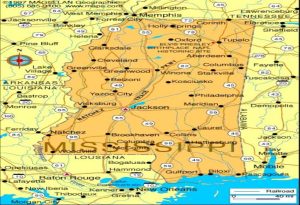
Mississippi is bordered by four states and the Gulf of Mexico. To the north lies Tennessee, while Alabama is to the east, Louisiana to the south, and Arkansas to the west, separated by the Mississippi River. Its geographic location plays a key role in its climate, biodiversity, and economic activities.
The state covers an area of approximately 48,430 square miles, making it the 32nd largest state in the U.S. It is divided into 82 counties, each with unique characteristics. The state’s terrain is predominantly flat or gently rolling, with fertile soil in the Mississippi Delta region and forested hills in the northern and eastern parts of the state.
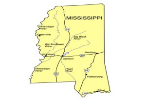
The Mississippi River
One of the most defining features of the state’s map is the mighty Mississippi River, which forms its western boundary. This river is not only a natural wonder but also a key economic artery. Historically, it has been vital for transportation, trade, and agriculture. Today, it remains a critical waterway for shipping and recreation.
The Mississippi River Delta, located in the northwest part of the state, is known for its fertile soil, which has made it an agricultural hub for centuries. Cotton, soybeans, and rice are among the primary crops grown in this region. The river also supports a variety of wildlife, including fish, migratory birds, and other species that thrive in its ecosystem.
Major Cities on the Map
Mississippi’s map showcases several urban centers, each contributing to the state’s identity:
- Jackson: The capital city, located in the central part of the state, is a hub for politics, culture, and education. Home to the Mississippi State Capitol, the city is known for its historical landmarks, museums, and vibrant music scene.
- Gulfport: Located along the Gulf of Mexico, Gulfport is the state’s second-largest city and a key port. Its proximity to the water makes it a center for fishing, shipping, and tourism.
- Biloxi: Adjacent to Gulfport, Biloxi is known for its casinos, beaches, and seafood industry. The city’s location on the Gulf Coast makes it a popular destination for both tourists and locals.
- Hattiesburg: Known as the “Hub City” due to its central location, Hattiesburg is home to the University of Southern Mississippi and offers a blend of educational, cultural, and recreational activities.
- Tupelo: Located in the northeast, Tupelo is famous as the birthplace of Elvis Presley. It’s a city steeped in musical history and Southern charm.
- Vicksburg: Situated on the banks of the Mississippi River, Vicksburg is renowned for its Civil War history, particularly the Siege of Vicksburg, which played a pivotal role in the Union’s victory.
Natural Features and Landmarks
Mississippi’s map is dotted with natural landmarks and features that highlight its ecological diversity. Some of the key areas include:
- The Mississippi Delta: Known as the birthplace of blues music, this region features flat, fertile plains that stretch for miles. It is an agricultural heartland and a cultural treasure trove.
- The Pine Belt: Located in southern Mississippi, the Pine Belt region is characterized by dense forests of pine trees. It is a major center for the timber and lumber industries.
- The Gulf Coast: Stretching along the southern edge of the state, the Gulf Coast is home to beautiful beaches, barrier islands, and estuaries. This area is popular for fishing, boating, and other recreational activities.
- Natchez Trace Parkway: This scenic route, which runs from Natchez to Nashville, Tennessee, follows an ancient Native American trail. It offers picturesque views of Mississippi’s natural beauty and historic landmarks.
Transportation and Infrastructure
Mississippi’s transportation network is well-represented on its map. Major interstates, highways, and railroads connect the state’s cities and towns, facilitating commerce and travel. Key transportation routes include:
- Interstate 55: Running north-south through the state, I-55 connects Jackson with Memphis, Tennessee, and New Orleans, Louisiana.
- Interstate 20: This east-west highway links Jackson to cities like Dallas, Texas, and Atlanta, Georgia.
- Interstate 10: Found in the southern part of the state, I-10 runs along the Gulf Coast, connecting Gulfport and Biloxi with other coastal cities.
- Highway 61: Known as the “Blues Highway,” this historic route runs through the Mississippi Delta, tracing the roots of blues music.
Railroads, such as those operated by Amtrak and freight companies, provide additional transportation options, while ports along the Mississippi River and Gulf of Mexico are vital for trade.
Cultural Insights
Mississippi is deeply rooted in history and culture, with its geography playing a pivotal role in shaping its identity. The state has a rich musical heritage, serving as the birthplace of blues, gospel, and country music. Towns like Clarksdale and Indianola are must-visit destinations for music enthusiasts exploring the blues trail.
Additionally, the state’s agricultural landscapes and river systems have influenced its cuisine, giving rise to Southern staples like catfish, cornbread, and barbecue. Festivals and events, such as the Mississippi State Fair and the Delta Blues Festival, celebrate this vibrant culture.
Conclusion
The map of Mississippi reveals a state that is as diverse as it is fascinating. From the fertile plains of the Delta to the bustling Gulf Coast and historic towns like Natchez and Vicksburg, the Magnolia State offers a rich tapestry of natural beauty, cultural heritage, and economic vitality. Exploring its geography not only provides insights into its physical landscape but also unveils the stories of the people and events that have shaped this unique region. Whether you’re a history buff, a nature lover, or a music enthusiast, Mississippi’s map is your guide to discovering the heart of the South.