
Map of Kentucky: Geography, History, and Key Features
Introduction
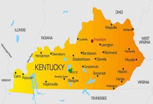
Kentucky, known as the Bluegrass State, is located in the southeastern region of the United States. It is bordered by seven states: Illinois, Indiana, and Ohio to the north; West Virginia and Virginia to the east; Tennessee to the south; and Missouri to the west. A map of Kentucky not only highlights its geographic location but also showcases its diverse topography, historical landmarks, and important cities. This article explores the map of Kentucky in detail, discussing its geography, major cities, transportation networks, and key attractions.

Geographic Features
Kentucky has a unique and varied landscape, which is reflected in its physical map. The state is divided into several geographic regions, each with distinct characteristics:
- Bluegrass Region – Located in the northern and central part of Kentucky, this area is characterized by rolling meadows and fertile soil, making it ideal for horse farms and agriculture. The state capital, Frankfort, and the largest city, Louisville, are situated in this region.
- Pennyroyal Region – Found in the south-central part of the state, this area features karst topography, which includes sinkholes, caves, and underground rivers. Mammoth Cave National Park, the longest cave system in the world, is a key attraction here.
- Appalachian Plateau – This region, in eastern Kentucky, is known for its rugged mountains, steep valleys, and coal reserves. It is home to part of the Appalachian Mountains and is rich in natural resources.
- Western Coal Fields – Located in the western part of the state, this area is known for its extensive coal deposits and flat terrain.
- Jackson Purchase – The far-western section of Kentucky, bordered by the Mississippi River, features low-lying wetlands and agricultural fields.
Major Cities and Population Centers
A political map of Kentucky highlights its major cities and urban centers. Some of the key cities include:
- Louisville – The largest city in Kentucky, Louisville is famous for the Kentucky Derby, bourbon distilleries, and a vibrant arts scene.
- Lexington – Known as the “Horse Capital of the World,” Lexington is a hub for equestrian activities, higher education, and the bourbon industry.
- Frankfort – The state capital, Frankfort is home to government buildings and historical sites.
- Bowling Green – This city is an economic and educational center, known for Western Kentucky University and the Corvette Assembly Plant.
- Paducah – Located near the confluence of the Ohio and Tennessee Rivers, Paducah has a rich history and a thriving arts community.
Transportation and Road Networks
Kentucky’s transportation infrastructure is well-developed, with several major highways and interstates connecting different parts of the state. Some of the key roadways include:
- Interstate 64 (I-64) – Runs east to west through Louisville, Lexington, and beyond.
- Interstate 65 (I-65) – Connects Louisville to Nashville, Tennessee, and Indianapolis, Indiana.
- Interstate 75 (I-75) – Runs north to south, linking Lexington to Cincinnati, Ohio, and Knoxville, Tennessee.
- Interstate 71 (I-71) – Connects Louisville to Cincinnati.
- Bluegrass Parkway and Western Kentucky Parkway – These parkways provide efficient routes between different regions of the state.
In addition to roadways, Kentucky has a strong network of railways, airports, and river transport systems that facilitate commerce and travel.
Natural Attractions and Landmarks
A topographic map of Kentucky reveals numerous natural attractions and landmarks that draw visitors to the state. Some of the most notable include:
- Mammoth Cave National Park – Home to the world’s longest cave system, this park offers extensive underground tours and hiking trails.
- Red River Gorge – A scenic area with natural rock formations, cliffs, and hiking trails, popular among outdoor enthusiasts and rock climbers.
- Land Between the Lakes National Recreation Area – This area features forests, lakes, and wildlife, providing opportunities for camping, boating, and hiking.
- Cumberland Falls – Known as the “Niagara of the South,” this waterfall is famous for its moonbow, a rare nighttime rainbow.
- Daniel Boone National Forest – A vast forest covering much of eastern Kentucky, offering outdoor recreation and stunning scenery.
Historical and Cultural Significance
Kentucky’s map also highlights numerous historical sites and cultural attractions, reflecting its rich heritage. Some key locations include:
- Fort Boonesborough – A historic site associated with Daniel Boone and early American pioneers.
- Abraham Lincoln Birthplace National Historical Park – Located in Hodgenville, this site commemorates the birthplace of the 16th President of the United States.
- Kentucky Bourbon Trail – A popular route through the state’s famous distilleries, showcasing the history and craftsmanship of bourbon-making.
- Churchill Downs – The site of the world-famous Kentucky Derby, held annually in Louisville.
Conclusion
A map of Kentucky reveals a state rich in geographic diversity, historical significance, and cultural vibrancy. Whether exploring its scenic landscapes, bustling cities, or historical landmarks, Kentucky offers a wealth of experiences for residents and visitors alike. Understanding the state’s geography helps appreciate its economic activities, transportation networks, and natural wonders, making it an essential destination in the United States.


